

Tar ball strand line at the wrack line at Ventura State Beach on May 30, 2015.
We have been getting lots of inquires about this crazy tarballing going on across Santa Barbara, Ventura, and Los Angeles Counties. I thought I would give a quick overview of tar balls in our part of the world; the Southern California Bight.

Just-deposited fresh tar ball at Zuma Beach, Los Angeles County. May 30, 2015.
Oil Seeps In Our History

Natural sandy beach oil seep in Santa Barbara. Image: USGS.
Oil has been deep underground for millions of years, more or less undisturbed. Indeed our sucking out all that stored carbon and then effectively spitting that carbon up into our atmosphere is the central driver of climate change and (what I like to call) global weirding (aka global warming). Petroleum is mostly the product of dead plankton and plants, not so much dead dinosaurs as the popular misconception normally goes (but I digress…). Oil and gas essentially build up in porous subsurface rock formations capped by impervious rock. This creates an oil and/or gas pocket which humans learned to tap beginning in the mid-to-late 1800s. But long before we ever learned to stick fancy metal straws down into these hydrocarbon rock pools, that “black gold” has been naturally leaking up to the surface since these formations first formed. These leaks or seeps happen when the overlying rock formations develop fractures or cracks in them, letting the oil or gas flow up to the surface quickly or slowly. Seeps have played important roles in human society for thousands of years.
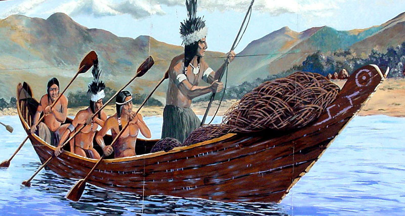
Chumash tomol. Image: www.missionscalifornia.com
Our local seeps in Santa Barbara and Ventura Counties featured most prominently in Chumash culture and technology. We have evidence of humans using seep tar at least as early as 5,000 B.C.E. with Chumash actively trading their tar with other, distant tribes for at least the past 1,000 years. Perhaps the most iconic use of the tar seeping from the ground across our region were the Chumash ocean-going tomols. These Chumash canoes were unusual and not constructed as a watertight vessel per se. Instead, these vessels were constructed of planks. Once assembled the final waterproofing included scooping up a bunch of tar from a local seep and then plastering/in-filling of any gaps between planks to create a superior seal and watertight boat. Spanish explorer Juan Rodriguez Cabrillo was particularly impressed with this technology and noted these unique canoes in the logs of his 1542 exploration of the Ventura and Santa Barbara coasts. Cabrillo even used Chumash tar to caulk and repair his own vessels. Our current Chumash people are active in preserving their traditions and culture and continue to construct traditional tomols to traverse the 17+ mile gap from the mainland to our channel islands.

Chumash arrive at Santa Cruz Island in a modern Tomol. Photo: National Park Service.

Summerland oil piers near Santa Barbara, circa 1901-1903. Image: Title Insurance and Trust / C.C. Pierce Photography Collection, USC Libraries.
Our first definitive confirmation of natural seeps depositing tar balls on our local beaches dates to 1772 and the journal of Padre Pedro Font (a member of Juan Bautista De Anza’s colonizing expedition). Font noted tar balls on the beach and slow motion seeps pouring asphaltum (which is just what it sounds like) down cliffs and bluffs into the ocean. With the European settlement of California, more modern extraction and uses of oil began to take hold. Oil extraction was initially concentrated at and near surface seeps where the emerging tar was scooped up directly, soon to be quarried as we traditionally mine gravel or other rocks. In those early days of the mid 1800’s, harvested tar was used principally to pave roads, fuel oil lamps, and as a lubricant for heavy machinery. From 1870-1890 more and more oil and gas wells sprang up as settlers encountered petroleum where they had hoped to find water in their boreholes. All heck broke loose following the first-in-the-world offshore oil production derricks (via long, wooden piers jutting out into the surf) off of Summerland in 1896. And the rest, as we say, is history.

Summerland offshore wells near the end of the play of this nearshore reservoir. Image: Museum of Ventura County.
An Ongoing Flow
Oil and gas seeps presents themselves both on the terrestrial surface and the ocean bottom. Flow can be highly variable, changing with seasons, tectonic pressures, temperatures, and a myriad of factors we poorly understand. This can complicate the source tracking when we are interested in figuring out if a tarring event or individual slick originated from a seep or a spill.

Remotely Operated Vehicle video still showsing a crab near the top of extruding tar on a tar mound in the Santa Barbara Channel. Lack of colonizing sessile organisms suggests that this mound is quite young. Image source: Lorenson, et al. 2009.

An approximately 3 m-long tarwhip extruding from an extensive tar mound offshore of Pt. Conception at a depth of 41 m. During this dive, many such tar whips were observed, all extruding from tar mounds. Some such whips broke off and floated to the surface while others did not retain buoyancy and fell to the ocean floor. Image source: Lorenson, et al. 2009.
Released oil and gas experiences a wide array of possible fates, including migration to the atmosphere, hanging out in the water column or surface layer, deposition upon the benthos, and degradation/transformation by the microbial community.

The fate of oil from a natural seep in the Santa Barbara Channel. Image source: Woods Hole Oceanographic Institution (2009).
Natural Oil Seeps in the Santa Barbara Channel
We have a wide range of naturally oil seeps across Ventura and Santa Barbara Counties. Examples of known seeps and some of the resulting slicks are below. You can also check out this killer site from the USGS documenting known seeps across California.

Southern California Bight showing possible oil slicks and seeps. Colors coded by confidence level where green>red>pink. Possible oil pollution slicks are seen in yellow tones. Image source: Fugro NPA Limited satellite mapping services.
An Ongoing Flow
One of the particular challenges with tracking surface slicks from seeps or spills revolves around the complicated surface currents and eddies we experience in the Santa Barbara Channel. This is due to both the geography of the Santa Barbara Channel, Point Conception, and the Transverse Range. As a result, we can get movement in virtually any direction, although we generally get migration eastward and southward during the spring and summer. To date, the surface slick from the Refugio Oil Spill has primarily migrated offshore with two main lobes, one going more or less straight offshore and a second migrating eastward down the coast. As of this writing, we have no direct evidence that oil from the Refugio Spill migrated any great distance. However the tar balling of beaches in Santa Monica Bay and the Ventura coastlines might have been translocated oil from that Refugio source. Below is an overview of the general surface flow patterns in the Santa Barbara Channel.

Dominant patterns of surface currents in the Santa Barbara Channel.
Seep or Spill?

Example tar ball chromatograms from the Santa Barbara Channel. Chromatograms of selected tarball samples. Total ion chromatogram (TIC) of aliphatic (A) and aromatic (B) fractions; Selected ion monitoring (SIM) chromatograms of m/z 191, Hopanes (C), and m/z 217, Steranes (D,E,F). Compounds identified in Table 2-1. Legend : MAS, monoaromatic steranes; Steranes, C26 to C29 regular steranes; Hopanes, C27 to C35 regular hopanes; BN, 28,30-bisonorhopane; UCM, Unresolved Complex Mixture. 23T, C23-tricyclic terpane; C24, C25, C27, C38, tricyclic terpanes; T, triplet, defined in text; Ts and Tm, defined in text; BN, bisnorhopane; ab29, ab30, ab31 through 35 (S & R epimers), ab-hopanes with carbon numbers; O, Oleanane; and G, Gammacerane. (D, E, F) Mass chromatograms (m/z 217) of C27, C28, and C29 steranes and C27 diasteranes in a selected coastal tar residues representing Families 22, 212, and 32. Legend: S,R = epimers of aaa27, 28, 29 and bb27, 28, 29 steranes. Image after Lorenson, et al. 2009.
The only definitive way to tell if the oil presenting itself on a given beach is from a seep or from an anthropogenic release (i.e. the Refugio Spill) is via chemical forensics. We do this by “fingerprinting” the oil. This essentially means grabbing the oil, getting it nice and liquid-y and then running those sample through a machine that can characterize the various chemical compounds. This analyzer can distinguish biomarkers or the “fingerprint” of amazingly complex organic compounds and the isotopes of individual carbon atoms that comprise a given oil sample. Frequent targets that will help with distinguishing the source formation include unusually “heavy” d13C, high C35 ab-hopane 22S and 22R epimers compared to C34, and prominent sulfur-containing PAHs, such as dibenzothiophenes. The last step is to run a sample of the candidate source oil (say from the Refugio Pipeline crude) and see if the two compounds’ peaks overlap.
Although the chemical components are common to essentially all tar balls, their relative proportions will vary with the oil sources. The chemical “fingerprinting” should use both the ratios of these array of constituents, plus additional markers from both aliphatic and aromatic hydrocarbons (see Hostettler et al., 2004).
The chemical composition of the tarballs also sheds light on their geochemical history. Despite tons of offshore, shallow seeps, and the constant impingement of tar onto the shoreline, little is known about the mechanics of the hydrocarbon formation in the shallow seeps, specific sources of tarballs, or their transport from the marine environment onto the shore.
While not perfect, this “fingerprinting” has been used to track not only the source of oil, but look at how that material has moved across our nearshore seascape. As we know that tar balls from offshore seeps can be transported significant distances from their sources by ocean currents, oceanographers have used tar ball source tracking to infer circulation patterns and nearshore currents. This amounts to researchers using oil as effectively a drifter.


Leave a Reply